|
|
THE TOWN OF DANUBEHERKIMER COUNTY, NY |

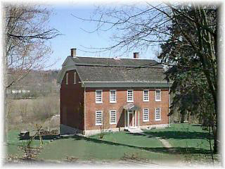
Home of General Nicholas Herkimer
Photo ©1999 Joyce Berry
The Town of Danube was formed April 17, 1817 from the Town of Minden, Montgomery County. On April 18, 1828 part of Danube was taken off to form the Town of Stark, Herkimer County. Settled by 1730, this town was a focal point of historical events, as noted by some of the definitive Palatine and other early surnames that still appear in the 1869 directory.
According to the 1869 Report of the Herkimer County Board of Supervisors:
"On the afternoon of the 17th (June), your Committee visited the town of Danube. Supervisor Smith and the Assessors of Stark accompanied us to this town. The land in this town is less broker and is better adapted to grain and dairying than that of Stark. In this town your Committee found better corn than in any other town in the county. The town extends to the Mohawk river and has some very fine valley lands. The town also extends westerly toward the village of Little Falls and embraces within its limits a large number of acres of a rocky hill, as seen from the river. There is one village, Newville, of about one hundred inhabitants. It has no incorporated companies. We were met at the hotel by Calvin Harder, Supervisor, Jacob P. Shaul, John Walrath, and Jacob Dillenback, Assessors, and several other citizens. In making the assessment, the Assessors have been in the habit of making small deductions for roads; yet we find the total number of acres returned nearly equal to the survey of the town. Real Estate is assessed at 25 percent. Cows are assessed at from twelve to eighteen dollars each. Farm buildings and fences are in good condition. The number of acres returned for this town in 1868 was 17, 337; in 1869, 17, 452 acres. The amount of Personal Property returned in 1868 was $51,607; for 1869, $74, 175, being an increase of $22,568 and an excess of the amount fixed by your Committee of $9,000. Several fine cheese factories are in town and about two thousand cows are miled in town." (Source: Proceedings of the Herkimer County Board of Supervisors, 1869; excerpt reprinted in 'Herkimer County at 200', Herkimer County Historical Society, Herkimer, NY: 1992)
DANUBE DIRECTORIES
GAZETTEER AND BUSINESS DIRECTORY OF HERKIMER COUNTY FOR 1869-70: DANUBE
Boyd's 1872-73 Business Directory of Danube - scroll to bottom of this page.
1888-1889 Danube Directory
EARLY DANUBE HISTORY
Early History of Danube
King Hendrick, the Great Sachem of the Mohawks
Dean Miller and Slavery in Herkimer County
DANUBE FAMILIES AND PERSONS OF NOTE
A Sketch of Some of the Prominent Families of the Town of Danube
Danube Family Sketches
DANUBE CHURCHES
Indian Castle Church: Little Known Facts
DANUBE VITAL RECORDS
Danube Births 1847 & 1849
Danube Marriages and Deaths 1847 & 1849
DANUBE CEMETERIES
Finks Basin Cemetery: Chris Andrle's partial reading
Fink's Basin Cemetery: Steven Knight's full reading
Herkimer Cemetery: Town of Danube
Herkimer Homestead Cemetery: Town of Danube
DANUBE MILITARY
Surviving Civil War Veterans and Widows from the 1890 Census
Revolutionary War Pension Application of John McMartin
Excerpt from Nathaniel S. Benton's "History of Herkimer County"
Albany, NY: J. Munsell, 1856. Page 391
Danube: Contains that part of the county bounded northerly by the Mohawk river, easterly by the bounds of the county, southerly by a line commencing at a point in the east bounds of the county, equidistant from the Mohawk river and the south bounds of the county, thence westerly parallel with the south bounds of the county to a line drawn from the easternmost lock of the old canal, on the north side of the Mohawk river, at the Little Falls, to the head waters of Lake Otsego, and westerly by the said last mentioned line.
Small Portions of the Fall Hill, Vaughns and L'Hommedieu patents, nearly the whole of Lindsey's, and parts of J. Vroman's, C. Colden's, Van Horne's and Lansing's patents are within the above boundaries.
This town, although of recent territorial organization, was no doubt one of the earliest settled by Europeans of any in the county, except those portions of it embracing Burnetsfield, or what was formerly known as the German Flats. The date of Lindsey's and Van Horne's patents, one in 1730 and the other in 1731, indicate this. It has been elsewhere stated in this work that Canajoharie mentioned in the early colonial history of the state, extended as far west as the foot of the Little Falls, in 1772, and probably farther before the German Flats district was set off. The casual reader of disjointed documents and isolated statements might infer that the Canajoharie mentioned in connection with the Mohawk tribe of Indians, was circumscribed in its limits to the town of that name in Montgomery county. This is clearly not the fact. The site of the upper Mohawk's castle is in this town, and near the present Indian castle church, now so called, and it has borne that name within the memory of the oldest inhabitants now living, and a uniform and unvarying tradition speaks to the same effect.
The French Itinerary, found in vol. 1 of the Documentary History of the State, fixes Fort Can-nat-ho-cary at the side of the Mohawk river, on the right bank, and four leagues from Fort Kouari (Herkimer). The writer was no doubt a French spy, sent out from Canada, in 1757, to make a topographical survey of the country, from Oswego to Schenectady and Albany, along the water communications from Lake Ontario to Hudson river. He describes the road on the north side of the river, that this fort is opposite to the mouth of the Canada creek.
The fort, so called, was one hundred paces on each side, had four bastions of upright pickets, fifteen feet high, about a foot square, and joined together with lintels. It was not surrounded by a ditch, but was constructed with port holes at regular distances, with a platform or stage all around, to fire from. There were some small pieces of cannon at each of the bastions, and a house at each curtain to serve as storehouses and barracks. There were several Indian families at this time living near this fort.
Sir Wm. Johnson, in Oct., 1772, speaks of having built a church, at his own expense, at the Canajoharees, and laments, that it is in a great measure useless, in consequence of not being able to secure the services of a missionary. I have not been able to fix the period, previous to the revolution, when the first church at the Indian Castle was built. The bell however, was highly regarded by the Indians, and they made an effort, during the war, to carry it off. They took it away in the night and secreted it. This, of course, caused excitement among the German population in the neighborhood, when it became known that the church bell had disappeared. How it was carried off, and what had become of it, engrossed the attention of all, and an immediate and careful search was made for the missing bell, in every direction; but the purloiners knew too well how to cover up and secure their trophy, to prevent a discovery. The search was fruitless, and the inhabitants had nearly given up all hope of its recovery when, one dark night, the sound of the bell was heard in the distance, and the population of the neighborhood were soon in hot pursuit, armed with guns, pitchforks and axes. The bell was recovered. The Indians, after they supposed the search was over, returned, and slung the bell upon a pole, and started with it, but did not secure that unruly member, the tongue or clapper; and the bell and clapper having an unequal momentum in the swing, when carried over uneven ground on a bending pole, came in contact, and by the ding dong sounds led to the discovery.
This town attracts considerable attention, in consequence of its containing the residence of Gen. Nicholas Herkimer; and, if it was not the birth place of the too celebrated Joseph Brant, a considerable number of the early years of his life were spent at the Indian Castle, with the members of his tribe, where an intimate acquaintance was cultivated between him and Gen. Herkimer, when they were young men. This fort must have been built in 1755; early in that year, Sir William Johnson speaks about constructing forts, at the two Indian castles, and notified Governor De Lancy of his having concluded a contract for their erection. These defenses were made to gratify the Mohawk Indians, who were exposed to the hostile incursions of the French and their Indian allies from Canada. I do not find any account of this fort twenty years afterwards, and if it had not entirely gone to decay before the revolution, it was probably used only as a temporary refuge of the inhabitants, to shield them against the hostile attacks of those for whose protection it was first erected.
In 1722, Governor Burnet, on the petition of the Rev. Petrus Van Driesen of Albany, granted a license authorizing Mr. Van Driesen to build a meeting house in the Mohawk country, for the use of the Indians, on any lands belonging to them. In 1737, a patent for 1000 acres of land was issued to the same gentleman, and it will be noticed that this grant covers lands at the mouth of the East Canada creek, and nearly opposite to the Indian Castle church. The mission at Fort Hunter had been established as early as 1712, and probably before that time, so that Mr. Van Driesen's license had no reference to that station.
I do not find any well founded data to change my conclusions that the church at German Flats was the first erection for religious worship in the county.
Fort Hendrick is marked on Sauthier's map of the province of New York, published in 1779, as being on the south side of the Mohawk river, opposite the mouth of East Canada creek. The Cannatjoharies are also marked as being located at this point. This establishes the fact that the site of the upper Mohawk castle was at the place above designated. And the name of the fort was a compliment to old King Hendrik, whose principal residence during the latter period of his life was at this place.
It should be observed that the grant of 4000 acres to Isaac Vrooman, and of 4000 acres to Ezra L'Hommedieu and Nathaniel Platt, in 1786, out of unpatented lands, by the crown, lying in this town and Stark, shows there must have previously existed very strong reasons for not granting those lands, long before the revolutionary war. These reasons are found in the fact, that they were Indian reservations, or rather, that being in the neighborhoods of one of the principal seats of the tribe, the Indians would not consent to part with them upon any terms.
The Mohawk Indians having left the country at the commencement of the war, and not returning as did the Senecas, Cayugas and Onondagas and sue for peace, were treated by the state as having abandoned all their rights as original possessors of the soil, and all the vacant lands within the limits formerly claimed by this tribe, were sold by the state without regarding the Indian title.
The only locality in this town called a village, is Newville, about four miles south from the river, on the Nowadaga creek, and at the foot of Ostrander's hill, from the top of which, at an elevation of 800 feet above the river, is a broad and extended view to the east and southeast, including the lower valley, of nearly thirty miles.
The description of the Town of Danube was typed by Kathleen Teague, who is researching her area Butler ancestors. For details on Kathy's Butler line, check out our acknowledgement to Kathy at the bottom of the Town of Russia 1824 Gazetteer section.
For more detailed information please refer to Nathaniel S. Benton's original 1856 'History of Herkimer County' or contact the Herkimer County Historical Society.
Danube, Herkimer Co.
Dievendorf L. cheese manuf
Moyer John, blacksmith
Owens D. grocer
Schuyler Felix, grocer
Newville, Herkimer Co.
Casler Peter C. blacksmith
Doxtader George, country store
Harred David, Exchange Bank
Houpt L. H. & C. honey
Jones Hamilton F. butcher
Lewis Francis, miller
Mower Christian, saw mill and factory
Snyder J. H. hotel
Tibbitts Wm. physician
Wagoner Stephen, cheese factory